|
|
Yucatan Peninsula
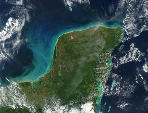
Topography, Climate, and VegetationThe Yucatán Peninsula is a low, undulating, limestone platform that is still gradually emerging from the sea. While the portions around Tikal have been above sea level for perhaps 10 million years, the northern tip of the peninsula, around Mérida, Yucatán, was under the sea until perhaps a million years ago. Northern Yucatan is low and relatively flat with no surface rivers or streams. At 17° to 21° north latitude, the peninsula sits within the "outer tropics"--an area where rainfall is generally substantially less, and more seasonal, than in the truly wet equatorial rain belt. With this modest, highly seasonal rainfall, vegetation of most of the Yucatán Peninsula is dryish tropical, broadleaf forest, rather than wet, evergreen rainforest. Rainfall is highest at the base of the peninsula and northward along the eastern shore, diminishing greatly to the north and west. Hence, from 3 meters of rain yearly in some portions of Guatemala and Belize, rainfall drops to less than 1 meter in the dry northwest corner of the peninsula near Merida, Yucatán. The forest varies in concert, being tall, complex, and only partly deciduous in the wetter areas, and reducing in stature to a low, deciduous, thorn-forest in the peninsula's dry northwestern regions. As is generally true in the tropics, rainfall in the Maya Forest follows the march of the sun, lagging behind somewhat, as it passes overhead twice yearly. There is a dramatic wet season/dry season cycle, with rains beginning in May or June, peaking in September, and waning thereafter. A severe dry season holds sway from February through April. The facts in this article are based on information
from the following: GeographyThe Yucatán Peninsula separates the Caribbean Sea from the Gulf of Mexico. It includes part of Mexico, the nation of Belize, and Guatemala's northern territory of El Petén. This website focuses on the Mexican portions of the peninsula. This includes three Mexican states - Yucatán, Campeche, and Quintana Roo. GeologyRocks along the coast are of Pleistocene and Holocene age, while older Miocene and Eocene deposits are exposed farther inland. Caves and karst features are common in nearly all parts of the Peninsula. The most notable karst feature is the cenote. Cenote is derived the Mayan word "dzonot" and refers to any subterranean chamber that contains permanent water. While some cenotes are vertical, water-filled shafts, others are caves that contain pools and underwater passageways in their interior. (Facts in this para from Cavebiology.com) Yucatan from SpaceA spectacular photograph of the peninsula taken from space. It includes Guatemala and Belize. ...link Both photos are courtesy of Visible Earth, NASA. |

